


Choose the size of your stop
Kirkjubæjarklaustur, often shortened to Klaustur, works well as a pause between Vík and the glacier country farther east. It can also be a destination in its own right. The useful decision is whether you want a village break with one nearby sight, or a walk that takes you above the village.
The regional tourism office places Klaustur at the centre of Skaftárhreppur, with access to both South Coast destinations and roads towards the Highlands. Those are different kinds of outing: a nearby place name does not mean a quick detour. [1]
| Your priority | A useful choice | What to allow for |
|---|---|---|
| A break during a driving day | Village services and Skaftárstofa | Opening hours and your onward journey |
| One nearby landscape stop | Kirkjugólf or Systrafoss | The signed approach, weather and return to the car |
| A longer outdoor outing | Ástarbrautin above the village | Climbing, descent, daylight and suitable footing |
Kirkjubæjarklaustur and nearby sights
On the map
Explore the locations using the links below.
OpenFreeMap · © OpenMapTiles · © OpenStreetMap
Village and sight area markers only. These are not parking entrances, walking routes or recommended standing positions. Follow signed access on the ground.
Location sources
- Kirkjubæjarklaustur village area · Visit South Iceland
- Kirkjugólf area · Visit South Iceland destination coordinate
- Systrafoss area · OpenStreetMap waterfall feature
Google Maps displays all locations as stops. Their order is not a suggested itinerary.
Start with the village, especially on a long driving day
Deal with food, fuel and the next part of your journey before starting a walk. If you are travelling with several people, agree whether this stop is primarily a rest or an activity. A meal and a short look at one sight may be a better fit than taking everyone onto a longer trail late in the day.
Skaftárstofa is the national park visitor centre at Sönghóll beside Route 1 near Klaustur. It also provides information about the municipality, with the exhibition Life with Nature. The park lists hours of 09:00 to 17:00 from 1 October 2026, checked for this article on 19 October. Check the centre’s own page before planning around a visit. [2]
Use the centre to ask about current local walking conditions and the outings you are considering. Take care with navigation results for Skaftárstofa and Skaftafellsstofa: the latter is the visitor centre at Skaftafell, farther east.
Kirkjugólf is natural rock, not a ruined church
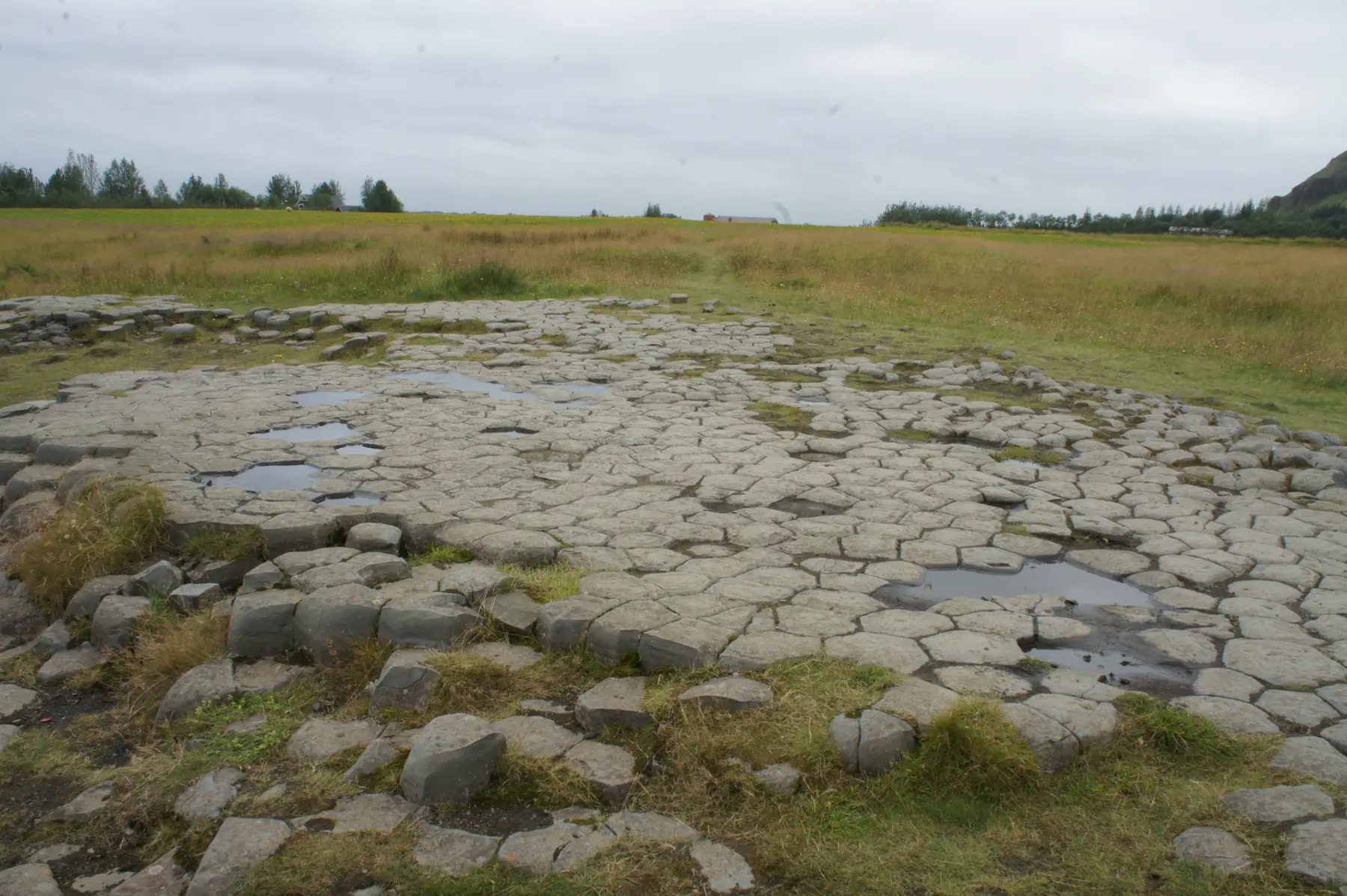
Kirkjugólf means church floor. The regular shapes are the exposed tops of basalt columns, rather than paving laid for a building. Visit South Iceland identifies a natural monument just east of the village and explains that no church ever stood on this spot. [4]
The Nature Conservation Agency describes a walking path from parking on Geirlandsvegur to the formation. Use that signed approach rather than stopping wherever a map pin seems closest. The agency says rangers at Skaftárstofa oversee the monument. [3]
Look at how the columns meet and how their upper surfaces have been worn. The agency explains that basalt contracts as it cools, forming columns; ice, waves and windblown sand later shaped the exposed surface. This is a place to look closely at a small patch of ground, rather than expect a tall cliff of columns. [3]
Follow the current signs and leave the rock in place. Our map marks the formation’s area, not its parking entrance or a route across the surrounding fields. The photograph dates from 2012 and is not an access guide.
Seeing Systrafoss and climbing above it are separate choices
Systrafoss drops from Systravatn over the hillside above Klaustur. The regional tourism account describes a path up towards the lake and a separate circular woodland path, Skógarstígurinn. Decide which outing you want before following a path uphill. [5]
For a brief visit, keep your plan focused on the waterfall area and the permitted paths that suit your group. You do not need to continue to the lake simply because other visitors are going that way. A view from below and a walk above the falls have different demands.
The map’s waterfall marker comes from the identified OpenStreetMap waterfall feature. It is for orientation, not a recommended standing position, crossing or parking place. Follow the local signs when you arrive.
Give Ástarbrautin its own time
The municipal visitor page describes Ástarbrautin, the Love Path, as a circular route of about 5 km. Its description includes a steep initial climb of about 80 metres and a fairly steep descent at Bjarnaklif. The route connects the upper landscape with sights including Systrafoss, Systravatn, Kirkjugólf and Stjórnarfoss. [6]
That makes it a walking outing to prepare for, rather than a flat extension of a village stroll. Ask for current route advice and use the waymarks on the ground. This article does not draw a track or give a fixed completion time, because your pace, surface conditions and stops determine the time you need.
Carry footwear and clothing suited to the whole return outing. Safetravel’s hiking guidance covers equipment, weather preparation and leaving a travel plan. In darker months, shorten the plan if daylight or footing does not support the full walk. A summer route description does not establish winter access. [7]
Keep the onward journey realistic
For a shorter landscape pause along Route 1, our Eldhraun lava field guide explains the official viewing area and why it should not be confused with a journey to the Laki craters.
Give nearby Fjaðrárgljúfur its own decision. Our canyon rim walk guide explains its road approaches and conservation guidance. It is a separate stop, not part of this village walk.
Likewise, treat a journey towards Lakagígar as a separate plan requiring current road and access checks. Klaustur being a gateway to the Highlands does not establish that those roads are open or suitable for your vehicle. Check Umferðin and the weather forecast before setting out. [8] [9]
If you are continuing from Vík towards Skaftafell, choose which place gets your main walk. Our Vík to Höfn itinerary helps you distribute those priorities across the journey. A longer Klaustur walk may be a reason to choose a shorter stop later.
Before leaving, check your accommodation’s actual arrival requirements and the remaining drive. Keep our Travel conditions page handy for dated snapshots and official links, then use the official services for decisions on the day.
Common questions
Is Klaustur the same place as Kirkjubæjarklaustur?
Yes. Klaustur is the commonly used shorter name for the village.
Can I see something without doing the full Ástarbrautin walk?
Yes. Plan a village break with one local sight, such as Kirkjugólf or the Systrafoss area. Follow its signed access and choose a turning point that suits your group.
Was Kirkjugólf a church floor?
No. Its name describes the appearance of naturally formed basalt columns. No church stood on the formation.
Does the map show the walking route?
No. It shows the village, Kirkjugólf and Systrafoss as area markers. The Google Maps stops are for orientation, not a walking itinerary.
Sources & useful links
Checked 19 October 2026. Trail access, weather and operator details can change.
- Visit South Iceland: Kirkjubæjarklaustur and its setting ↗
- Vatnajökull National Park: Skaftárstofa and current opening hours ↗
- Nature Conservation Agency: Kirkjugólf access and geology, in Icelandic ↗
- Visit South Iceland: Kirkjugólf ↗
- Visit South Iceland: Systrafoss and the woodland paths ↗
- Visit Klaustur: Ástarbrautin route description ↗
- Safetravel: hiking preparation ↗
- Icelandic Road and Coastal Administration: road information ↗
- Icelandic Meteorological Office: forecasts and warnings ↗