


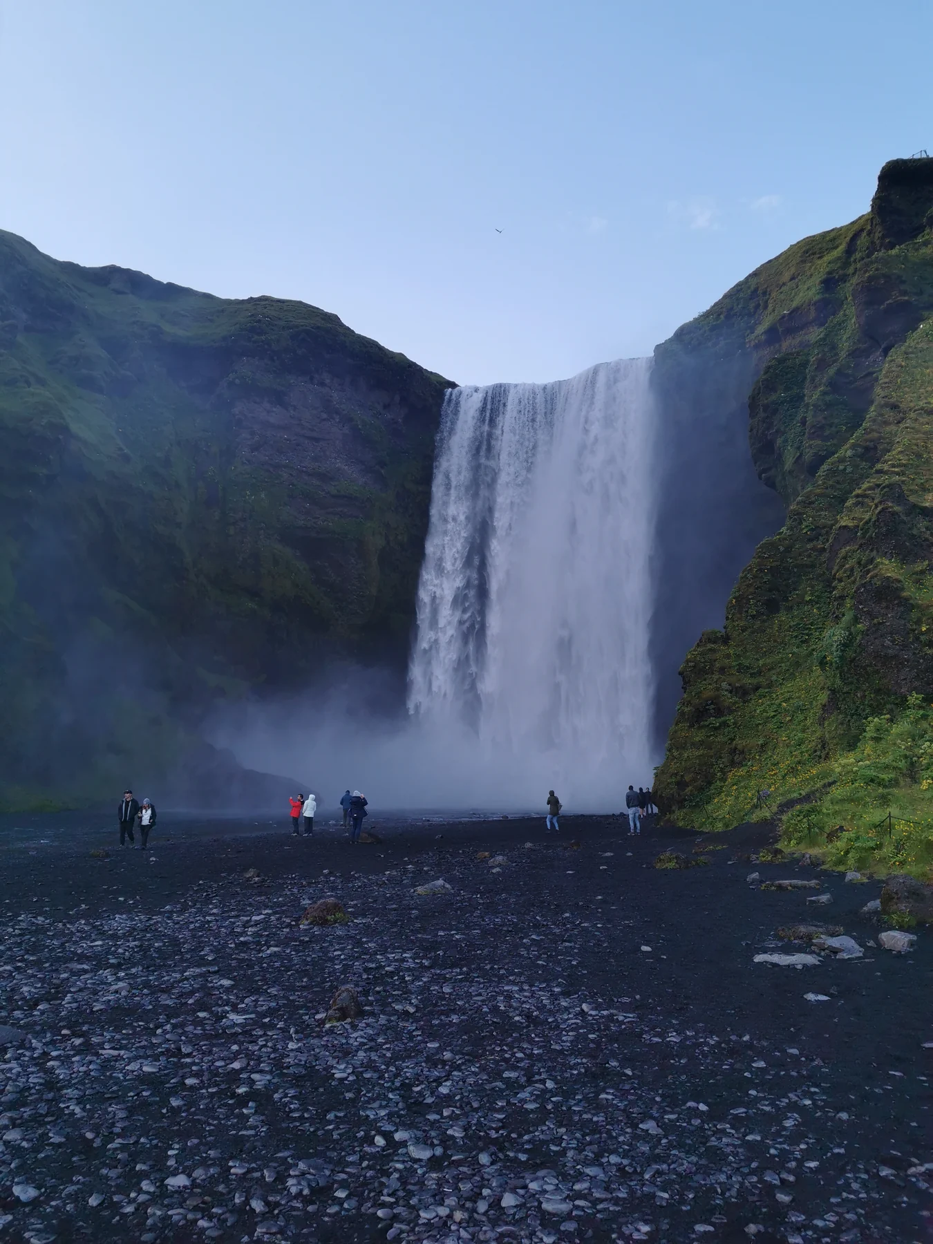
Choose the size of your visit
Skógafoss can be a brief waterfall stop, a climb to the upper viewpoint or the beginning of a serious mountain journey. Treating those as three different plans is more useful than allowing one visit to expand without enough time or equipment.
| Your plan | What it includes | Decide before arriving |
|---|---|---|
| Base view | See the full waterfall from river level | Whether spray and wet ground suit your group |
| Upper viewpoint | Climb the steps and return the same way | Whether the steps and current conditions suit everyone |
| Long trail | Continue into the mountain route beyond the waterfall | Whether you have a complete hiking plan |
Visit South Iceland places Skógafoss at Skógar beside Road 1 and records a height of 60 metres. Its published coordinates identify the destination, not a parking space or a safe line to the water. [1]
The official national visitor guide describes Skógafoss as close to the Ring Road. That makes it easy to include in a South Coast journey, but it does not make every part of the visit equally simple. [3]
South Iceland
On the map
Explore the locations using the links below.
OpenFreeMap · © OpenMapTiles · © OpenStreetMap
Destination marker only. This is not a parking entrance, walking route or viewpoint location. Follow current signs and local directions.
Location sources
Start with the view from the base
The base gives the clearest view of the whole curtain of water and the cliffs around it. Begin far enough back to take in the scene. Moving closer increases the spray and can make the ground much wetter, without always improving the view.
Wear an outer layer that can handle spray and keep cameras and phones secure. Do not use another visitor’s position as evidence that a wet or uneven approach is suitable for you. Water levels, wind and footing can change the experience.
If someone in your group does not want to climb the steps, make the base the shared visit. The upper viewpoint should be an optional extension, not the measure of whether the stop was worthwhile.
Decide whether to climb to the upper viewpoint
The path beside the waterfall leads to the top and continues upstream along the Skógá river. The official destination page confirms that connection, but it does not provide a universal difficulty rating for the steps. Judge the climb from the conditions you find and your group’s comfort with stairs. [1]
Wind, rain, ice and tired legs can all change a straightforward looking climb. Keep both hands available, give other people room and turn back if the steps do not suit you. A photograph from above is not worth forcing the climb.
At the upper area, stay within the established visitor space and follow signs and barriers. The river and cliff edge need distance even when the viewpoint is busy. Return by the same steps unless you have deliberately prepared for a longer walk.
Treat the long trail as a separate mountain plan
The path above Skógafoss is also the southern start of the Fimmvörðuháls route. Visit South Iceland describes a journey of about 20 kilometres, with an estimated 8 to 12 hours and about 1000 metres of ascent and descent. It also warns that weather can change suddenly between Eyjafjallajökull and Mýrdalsjökull. [2]
Reaching the top of the waterfall does not mean you are prepared to continue across the pass. The complete route needs its own transport, weather, daylight, equipment and emergency plan.
If you only want a little more time by the river, decide your return point before continuing and stay within current local guidance. Do not copy a distance from another visitor and do not let a short extension become an unplanned mountain hike.
For the complete route, read current hiking information and arrange the transport at both ends before setting out. Check Safetravel and the weather office close to departure rather than relying on this dated guide. [5] [7]
Check the practical details before you arrive
Parking
Skógafoss has paid parking. Parka operates a current payment page for the site and states that payment follows the valid tariff. Check the signs, vehicle category, time limit and payment instructions when you arrive. This guide does not repeat a price because tariffs can change. [4]
Weather and roads
Check the official road map and weather forecast as part of the same decision. A waterfall stop beside Road 1 can still be uncomfortable or unsuitable when wind, ice or road conditions change. Use Umferðin, the Icelandic Meteorological Office and Safetravel. Our Travel conditions page brings dated official snapshots together but is not an emergency service. [5] [6] [7]
Give the stop a clear place in your day
For local history alongside the waterfall, our Skógar Museum guide compares the folk and transport collections with the historic buildings outdoors, with current museum hours and admission.
Combining waterfalls on the western South Coast? Our Seljalandsfoss and Gljúfrabúi guide separates the main view from the path behind the falls and the neighbouring canyon, with current parking information.
When travelling between Reykjavík and Vík, choose Skógafoss as a main stop rather than squeezing it between several waterfalls and a fixed activity. Our Sólheimajökull guide helps if a glacier visit is also under consideration, while the Vík guide helps you leave time for the village and the coast.
Do not rely on assumed opening hours for nearby food, toilets or museums. Check the current operator page for any service you need. Carry drinking water and a dry layer even when you expect a short visit.
Common questions
Can I see Skógafoss without climbing the steps?
Yes. The base view is a complete waterfall visit. Treat the upper viewpoint as a separate choice for people who are comfortable with the steps and current conditions.
Is parking free?
No. Parka operates a current payment page for Skógafoss. Read the signs and current tariff for your vehicle rather than relying on an older price.
Does the trail end at the upper viewpoint?
No. A route continues beside the Skógá river and forms part of the much longer Fimmvörðuháls journey. Only continue with a deliberate plan that fits current conditions.
Does the map show where to park or walk?
No. It marks the official destination coordinates only. Follow current signs for parking, paths and permitted visitor areas.
Sources & useful links
Checked 7 October 2026. Trail access, weather and operator details can change.
- Visit South Iceland: Skógafoss ↗
- Visit South Iceland: Fimmvörðuháls ↗
- Visit Iceland: the South Coast ↗
- Parka: current Skógafoss parking payment page ↗
- Safetravel: current travel information ↗
- Icelandic Road and Coastal Administration: road information ↗
- Icelandic Meteorological Office: forecasts and warnings ↗